
The emergence of drone technology and drone mapping has revolutionized the way land surveys are conducted. Drones can be used to collect and analyze data quickly and easily without the need for manual labor or expensive equipment. As a result, drone mapping offers significant advantages over traditional surveying techniques. Read on to learn more about five of these key benefits.
1) Improved Safety
Safety is a top priority on construction sites. Heavy construction equipment and remote surveying locations using traditional surveying methods can present potential danger for personnel walking the site. Drone mapping minimizes time and personnel on an active construction site as drones can be operated from outside of construction zones with pinpoint accuracy. As such, drones can access hazardous or difficult-to-reach areas without putting personnel at risk.
2) Reduced Cost and Time
Drone mapping is also much cheaper and faster than traditional surveying methods. Drone mapping projects can be completed in a fraction of the time of traditional surveying methods. Instead of walking a site shooting points every few feet, drones fly above the site capturing thousands or even millions of data points. What may take days using traditional surveys can be done in a matter of hours with a drone. Time saved equals money saved.
3) In-Depth Data Collection
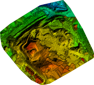
Traditional surveying methods are limited by the X,Y,Z location information they can collect. Drones combine location data into a variety of sources including high resolution images and 3D models to provide an in-depth look at a construction site. This helps construction engineers get a better understanding of the terrain and features of the project.
4) Comprehensive Data Analysis
Drone mapping also enables comprehensive data analysis that is not possible with traditional surveying methods. By collecting detailed data from multiple sources, surveyors can build comprehensive 3D models to generate real-time insights into their projects. Data collected with a drone can be measured down to the pixel resulting in point clouds with thousands or even millions of measurable points. This helps improve decision making while reducing potential risks associated with human error.
5) Enhanced Accuracy
Drone mapping can also greatly enhance accuracy. By capturing high resolution orthographic images georeferenced with ground control points, drones be used to provide exact measurements down to a couple of centimeters. This data can be used for everything from site planning to volumetric measurement. This level of accuracy is invaluable as it can ensure that projects are built on time and on budget.
Drone mapping offers many advantages over traditional surveying methods. Improved safety, reduced cost and time, in-depth data collection, comprehensive data analysis and enhanced accuracy are just a few of the key benefits drone mapping has over its more manual counterpart.
Ready to incorporate drone technology into your next construction project? Contact us at jim@chesapeakeaerialphoto.com or 443-384-7427 to learn more about how we can help.